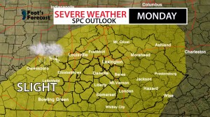
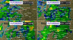
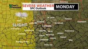
I’m updating late on this Sunday evening, hope your weekend is going well. I think that now its safe to say that October is probably one of my busiest months this year. Earlier this week we experienced a rare tornado outbreak across the area, and secondly I’ve been tracking those rain amounts across southern and eastern Kentucky. Several spots have picked up nearly 2-4 inches of rainfall, and that’s all cumulative over the past couple of days. Monday Night , we have this southern return flow of moisture and I’m also tracking an inversion layer across the Missouri valley, which is trapping in an uninterrupted flow of energy, but because of the dynamic front that will stroll in; If we hodgepodge these things together, and we get a fall type set-up of severe weather, pretty similar to last week, but hopefully not as bad as last week’s tornado outbreak. I’m not promising anything but there is enough spin to put down a few tornadoes for you folks in extreme south western Kentucky. Lexington, the slight risk isn’t over us yet, we have at least 12-24 more hours before the SPC considers us under a slight risk.
The Key threats are:
– Damaging Winds
-Tornadoes
-Hail
I’m Forecaster Darius Mack, more updates to come tomorrow!
Fall

I‘M UP READY TO ROLL #KYWX
7:00 AM October 06,2014
Well we may have just ran short of fall over the weekend, our first Frost Advisory for the commonwealth, and as sponge bob would say “ The best time to wear a striped sweater, is all the time!”, well that was certainly the case, you get to pick whether or not to wear the turtle neck. This morning, I’m issuing a “Hot Coco” advisory, there’s no frost, but the air is at a brisk. We warm it back up, especially on Tuesday as highs will surge back into the 70s, as a compensation. Rain chances are on the rise, and we have a severe weather risk. I’m not expecting anything in terms of Spring like Severe weather, but more like a Fall set-up.

TODAY: First, I’m tracking a Jet stream which will act as a reinforcement to those showers and storms that will move across Southern Kentucky and the Tennessee valley areas. Several waves of energy will pivot across the Mississippi valley lands, ahead of the actual front that will persist eastward. First round comes in later this morning, the second one comes in this afternoon, then the third. Watching out for rush-hour, that’s the timing we can expect some louder natured storms through the region. There is enough spin to maybe put down a few spin up tornadoes across the I-65 corridor later on this afternoon, doesn’t mean that I’m promising anything, but that is something our team is monitoring. Highs today will top around 65-68 degrees area wide.


*The STORM PREDICTION CENTER HAS PLACED most of central Kentucky under a slight risk for SEVERE WEATHER, Here are the things to watch out for:
-Damaging Winds
-Isolated Tornadoes
TUESDAY: 71 degrees for the high with more storms in the forecast.
Stick with the team for the latest, Chris, Kyle, and I may be joining back with you later this evening. If you have any questions contact me at DariusMack.FootsForecast@mail.com or DM me on twitter!
-Forecaster Darius Mack
Twitter:@dariusmack_wx
